This was our
fourth year on the Wales Coast Path. It should have happened last year but a
stress fracture had prevented Phil from venturing out. But all was well now; we
were both fit and ready to go. Our great friend Dot had volunteered to take us
over to Wilmslow Station to catch the 10.47 to Haverfordwest. This train duly
arrived on time and we found that the station in Haverfordwest was  not in the
centre of the town. On walking into the centre, we were directed to the bus
station from which we were reliably informed, by bus drivers no less, that the
bus to Pembroke departed. It was only when this failed to appear that we
approached a young lady who walked us around a shopping centre to show us the
correct departure point. So, now an hour behind schedule, we took the bus to
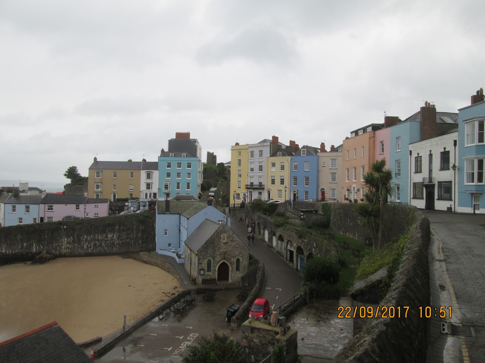
Pembroke and the flat that we had booked for the next three nights. This turned
out to be a splendid apartment above Long Meadow Bakery on the main street. We
had time for a meal in the Old Kings Arms, roast belly pork & garlic potatoes
followed by apple & blackberry crumble & ice cream, washed down with Bowled
Over (4.5 %) from Wadsworth’s, and then turned in after a long day.
not in the
centre of the town. On walking into the centre, we were directed to the bus
station from which we were reliably informed, by bus drivers no less, that the
bus to Pembroke departed. It was only when this failed to appear that we
approached a young lady who walked us around a shopping centre to show us the
correct departure point. So, now an hour behind schedule, we took the bus to
Pembroke and the flat that we had booked for the next three nights. This turned
out to be a splendid apartment above Long Meadow Bakery on the main street. We
had time for a meal in the Old Kings Arms, roast belly pork & garlic potatoes
followed by apple & blackberry crumble & ice cream, washed down with Bowled
Over (4.5 %) from Wadsworth’s, and then turned in after a long day.
 not in the
centre of the town. On walking into the centre, we were directed to the bus
station from which we were reliably informed, by bus drivers no less, that the
bus to Pembroke departed. It was only when this failed to appear that we
approached a young lady who walked us around a shopping centre to show us the
correct departure point. So, now an hour behind schedule, we took the bus to
Pembroke and the flat that we had booked for the next three nights. This turned
out to be a splendid apartment above Long Meadow Bakery on the main street. We
had time for a meal in the Old Kings Arms, roast belly pork & garlic potatoes
followed by apple & blackberry crumble & ice cream, washed down with Bowled
Over (4.5 %) from Wadsworth’s, and then turned in after a long day.
not in the
centre of the town. On walking into the centre, we were directed to the bus
station from which we were reliably informed, by bus drivers no less, that the
bus to Pembroke departed. It was only when this failed to appear that we
approached a young lady who walked us around a shopping centre to show us the
correct departure point. So, now an hour behind schedule, we took the bus to
Pembroke and the flat that we had booked for the next three nights. This turned
out to be a splendid apartment above Long Meadow Bakery on the main street. We
had time for a meal in the Old Kings Arms, roast belly pork & garlic potatoes
followed by apple & blackberry crumble & ice cream, washed down with Bowled
Over (4.5 %) from Wadsworth’s, and then turned in after a long day.
Thursday 5th September 2019 Bosherston – West Angle Bay
A Day on the Ranges
Our flat was
perfectly situated. The bus stop for the coastal cruiser was opposite the town
hall, no more than a two-minute walk down the street. But we had to be up and
ready for the 08.42 morning service. This arrived spot on time. And lo and
behold, the driver was Gordon, the guy who had picked us up two years ago from
the end of our previous expedition. It was like meeting an old friend as conversation
flowed between Gordon and his passengers. Before 9 o’clock, we were back at
Bosherston and ready to walk. This time however we did not have heavy packs on.
We could travel light for two days, with our kit left in our Pembroke apartment.
 We set off
towards Broad Haven and the point we had left the coast path in 2017. This time
we walked through the lily ponds which looked magical in the morning sunshine.
Crossing the beach, we soon gained the car park at Trefalen and our journey
round the Welsh coast, after a two year gap, recommenced. We had a brief and
wonderful cliff walk around to St Govan’s Chapel, a tiny ruin of a church
clinging to the cliff-face, hidden from view down some steep uneven steps. We
met a South African couple who were on holiday with their dogs. After climbing
back up to the top of the cliffs we were met by a soldier, a red flag and a no
entry sign. The Castlemartin ranges were firing and were closed to walkers. The
diverted route involved a return by road to Bosherston and then a series of
tracks and lanes around the edge of the firing range. The route was waymarked
as the Castlemartin Range Trail, an off-road alternative along field paths and
grass verges with the sound of gun fire in the distance.
We set off
towards Broad Haven and the point we had left the coast path in 2017. This time
we walked through the lily ponds which looked magical in the morning sunshine.
Crossing the beach, we soon gained the car park at Trefalen and our journey
round the Welsh coast, after a two year gap, recommenced. We had a brief and
wonderful cliff walk around to St Govan’s Chapel, a tiny ruin of a church
clinging to the cliff-face, hidden from view down some steep uneven steps. We
met a South African couple who were on holiday with their dogs. After climbing
back up to the top of the cliffs we were met by a soldier, a red flag and a no
entry sign. The Castlemartin ranges were firing and were closed to walkers. The
diverted route involved a return by road to Bosherston and then a series of
tracks and lanes around the edge of the firing range. The route was waymarked
as the Castlemartin Range Trail, an off-road alternative along field paths and
grass verges with the sound of gun fire in the distance.
At Merrion
we were back on the road that ran as straight as a die passed the camp. At the
main entrance were two old WW2 tanks, one a German tank presented by the departing
German Panzer  Division based here for 35 years. We stuck to the road as far as
Castlemartin village where we stopped for a short rest. Then more field paths
took us onto the road above Gupton Farm as the dramatic view of Freshwater West
unfolded. We had a sumptuous beef burger, smothered in kelpchup, from a mobile
kiosk, Café Mor. This gave us added energy to traverse a five-mile section of
cliffs to West Angle Bay. We arrived with 15 minutes to spare to catch the bus,
driven as always by Gordon, back to Pembroke.
Division based here for 35 years. We stuck to the road as far as
Castlemartin village where we stopped for a short rest. Then more field paths
took us onto the road above Gupton Farm as the dramatic view of Freshwater West
unfolded. We had a sumptuous beef burger, smothered in kelpchup, from a mobile
kiosk, Café Mor. This gave us added energy to traverse a five-mile section of
cliffs to West Angle Bay. We arrived with 15 minutes to spare to catch the bus,
driven as always by Gordon, back to Pembroke.
 Division based here for 35 years. We stuck to the road as far as
Castlemartin village where we stopped for a short rest. Then more field paths
took us onto the road above Gupton Farm as the dramatic view of Freshwater West
unfolded. We had a sumptuous beef burger, smothered in kelpchup, from a mobile
kiosk, Café Mor. This gave us added energy to traverse a five-mile section of
cliffs to West Angle Bay. We arrived with 15 minutes to spare to catch the bus,
driven as always by Gordon, back to Pembroke.
Division based here for 35 years. We stuck to the road as far as
Castlemartin village where we stopped for a short rest. Then more field paths
took us onto the road above Gupton Farm as the dramatic view of Freshwater West
unfolded. We had a sumptuous beef burger, smothered in kelpchup, from a mobile
kiosk, Café Mor. This gave us added energy to traverse a five-mile section of
cliffs to West Angle Bay. We arrived with 15 minutes to spare to catch the bus,
driven as always by Gordon, back to Pembroke.
Bosherston
dep. 08.58, Trefalen 09.30, West Angle Bay arr. 15.55
16.97 miles GPS
in 6hr 16m 42s walking time plus 40 minutes at Freshwater West at Café Mor.
We ate in
the Royal George, Pembroke. I had battered hake, chips & peas followed by
jam & coconut sponge & ice cream. The beer was Wainwright (4.1%) from
Thwaites.
Friday 6th September 2019
West Angle Bay – Pembroke Dock
Block Houses and Power Stations
The same bus
at the same time with the same driver took us back to West Angle Bay in the
morning. A full commentary from Gordon added to the pleasure of the journey. We
learnt more about the German Panzer Division based at Castlemartin and the
National Trust farm at Gupton. During the  night a wind had arisen and when some
passengers tried to get off the bus at Freshwater West, they were blown back by
the blast. At West Angle, the sand was driving across the car park making
walking very unpleasant until we were onto the headland with the wind behind
us. We had not expected any refreshments today but we had only been walking for
half an hour when there in front of Chapel Bay fort was a ‘café open’ sign
leading us into the fort and its museum. This provided us with a surprising and
substantial breakfast.
night a wind had arisen and when some
passengers tried to get off the bus at Freshwater West, they were blown back by
the blast. At West Angle, the sand was driving across the car park making
walking very unpleasant until we were onto the headland with the wind behind
us. We had not expected any refreshments today but we had only been walking for
half an hour when there in front of Chapel Bay fort was a ‘café open’ sign
leading us into the fort and its museum. This provided us with a surprising and
substantial breakfast.
 night a wind had arisen and when some
passengers tried to get off the bus at Freshwater West, they were blown back by
the blast. At West Angle, the sand was driving across the car park making
walking very unpleasant until we were onto the headland with the wind behind
us. We had not expected any refreshments today but we had only been walking for
half an hour when there in front of Chapel Bay fort was a ‘café open’ sign
leading us into the fort and its museum. This provided us with a surprising and
substantial breakfast.
night a wind had arisen and when some
passengers tried to get off the bus at Freshwater West, they were blown back by
the blast. At West Angle, the sand was driving across the car park making
walking very unpleasant until we were onto the headland with the wind behind
us. We had not expected any refreshments today but we had only been walking for
half an hour when there in front of Chapel Bay fort was a ‘café open’ sign
leading us into the fort and its museum. This provided us with a surprising and
substantial breakfast.
Suitably
reinvigorated, we were ready to tackle the long day ahead. The coast path
continued around Angle Point before cutting back into Angle village via the Old
Point House pub. It took an age to circumnavigate Angle Bay, the view being
dominated by the oil refinery ahead. The field path emerged onto a tarmac road
which led back to the coast at Popton Fort. From here the refinery was  out of
sight and hidden except for pipe lines running down to the jetty. The sky was
darkening and there was a threat of rain as we turned inland to the delightful
old church at Pwllcrochan. A wooded path skirted the power station which is one
of the largest gas-fired stations in Europe. A shower of rain made us pause to
don waterproofs but these were not worn for long. The village of Hundleton is
by-passed by the footpath which loops back to the coast before emerging in
Monkton. A mile of urban pavements brought us to the castle at Pembroke and the
bridge across the river.
out of
sight and hidden except for pipe lines running down to the jetty. The sky was
darkening and there was a threat of rain as we turned inland to the delightful
old church at Pwllcrochan. A wooded path skirted the power station which is one
of the largest gas-fired stations in Europe. A shower of rain made us pause to
don waterproofs but these were not worn for long. The village of Hundleton is
by-passed by the footpath which loops back to the coast before emerging in
Monkton. A mile of urban pavements brought us to the castle at Pembroke and the
bridge across the river.
 out of
sight and hidden except for pipe lines running down to the jetty. The sky was
darkening and there was a threat of rain as we turned inland to the delightful
old church at Pwllcrochan. A wooded path skirted the power station which is one
of the largest gas-fired stations in Europe. A shower of rain made us pause to
don waterproofs but these were not worn for long. The village of Hundleton is
by-passed by the footpath which loops back to the coast before emerging in
Monkton. A mile of urban pavements brought us to the castle at Pembroke and the
bridge across the river.
out of
sight and hidden except for pipe lines running down to the jetty. The sky was
darkening and there was a threat of rain as we turned inland to the delightful
old church at Pwllcrochan. A wooded path skirted the power station which is one
of the largest gas-fired stations in Europe. A shower of rain made us pause to
don waterproofs but these were not worn for long. The village of Hundleton is
by-passed by the footpath which loops back to the coast before emerging in
Monkton. A mile of urban pavements brought us to the castle at Pembroke and the
bridge across the river.
Rather
cruelly we marched on passed a waterside café but the end on the day was in sight.
A climb through some woods led to another suburb, Pennar, and a very steep road
led up to a wonderful viewpoint over Pembroke Dock and its ferry port. A poorly
signed section led us steeply down into the town and we walked passed the
imposing walls of the fort and on to the Asda supermarket, the end of our day’s
walk. A straight road back into the town centre took us to the train station
and the adjoining bus stop. It was a ten minute bus ride back to Pembroke Town
Hall and our home for the duration. The
weather had cleared and, after our showers, we walked back to the river under a
cloudless sky. It was our last night in Pembroke.
West Angle
Bay dep. 09.36, Pembroke Dock arr. 16.30
17.77 miles GPS
in 6hr 04m 31s moving time plus a 40minute (10.20 –11.00) stop in the café at
Chapel Bay Fort.
We ate at
the Watermans Arms, Pembroke. Chicken, bacon and mushroom puff with chips,
followed by syrup sponge & ice cream. The beer was Landlords (4.1%) from
Timothy Taylor
Saturday 7th September 2019 Pembroke Dock – Dale
Waiting for Low Tide
Our third
and final early morning bus ride took us in the opposite direction. The bus
back to Pembroke Dock went from in front of Pembroke Castle and soon dropped us
at the station. We were in no hurry today because of the tides, so we had a
leisurely breakfast in the Hasty Bite café. Then we retraced our steps of
yesterday back to Asda and regained the line of the coast path. Just before the
Cleddau Bridge, we past the burnt-out buildings that had until recently been a
large hotel. Up on the bridge, the path shared the pavement with cyclists, some
of which were serious and fast-moving. The sun was out now and it was getting
really warm. We reached the north side of the viaduct and were able to slip
down the side of the road and onto a narrow woodland path which eventually
brought us out into Neyland. This looked as if it had seen better days and we
were glad to get through the quiet streets and into Hazelbeach and the short
climb passed Llanstadwell church.
A brief rehydration
break was called outside the Ferry Inn, a pub in a lovely setting, but which
was closed at this early hour. So on we pressed uphill and passed another oil
refinery. The oil pipelines leading down to the sea were crossed on enclosed caged
walkways. At the end of the industrialised  section of coastline, the route
turned inland back to the road at Venn Farm and then dropped down to Black
Bridge and into Milford Haven. This was a more pleasant place than I had expected
with grand houses on the seafront and a bustling town centre of shops, hotels
and b&bs. We had lunch at the Bus Stop Cafe, pulled pork panini and
cappuccino. Here we studied the tide tables at some length. We had two
estuaries to cross this afternoon and could save ourselves long diversions by
hitting a time window around low tide.
section of coastline, the route
turned inland back to the road at Venn Farm and then dropped down to Black
Bridge and into Milford Haven. This was a more pleasant place than I had expected
with grand houses on the seafront and a bustling town centre of shops, hotels
and b&bs. We had lunch at the Bus Stop Cafe, pulled pork panini and
cappuccino. Here we studied the tide tables at some length. We had two
estuaries to cross this afternoon and could save ourselves long diversions by
hitting a time window around low tide.
 section of coastline, the route
turned inland back to the road at Venn Farm and then dropped down to Black
Bridge and into Milford Haven. This was a more pleasant place than I had expected
with grand houses on the seafront and a bustling town centre of shops, hotels
and b&bs. We had lunch at the Bus Stop Cafe, pulled pork panini and
cappuccino. Here we studied the tide tables at some length. We had two
estuaries to cross this afternoon and could save ourselves long diversions by
hitting a time window around low tide.
section of coastline, the route
turned inland back to the road at Venn Farm and then dropped down to Black
Bridge and into Milford Haven. This was a more pleasant place than I had expected
with grand houses on the seafront and a bustling town centre of shops, hotels
and b&bs. We had lunch at the Bus Stop Cafe, pulled pork panini and
cappuccino. Here we studied the tide tables at some length. We had two
estuaries to cross this afternoon and could save ourselves long diversions by
hitting a time window around low tide.
With high
tide at 1pm, I planned to arrive at the first of these crossings at 4pm. It was
such an easy walk around the clifftops that we actually arrived at Sandy Haven
at 3.45pm, and sure enough the  stepping stones and footbridge were underway.
But the tide was receding fast and we were able to follow the retreating water’s
edge out into the river where submerged structures were becoming visible. It
was nearly 5pm before we splashed across through half an inch of water and up
onto the western shore. We rang ahead to warn our landlady that we would be
late arriving in Dale and we set out on a 5½ mile cliff top walk round to the
second of the estuaries. This of course was completely water-free but the
direct route took us across an ankle breaking stony beach which took its toll
on Phil’s knees. A notice board had warned us that the boardwalks across the
stream had been damaged in a storm but a couple on the beach told us that
repairs had been affected. So we pressed on and crossed with dry feet to find
ourselves a mile or so from Dale village. It was just 7pm as we entered the
village and we were relieved to see the Allenbrook name on a gate. We walked up
a shaded drive to a wonderful country house in beautiful gardens with peacocks
and rare breed hens roaming around: an idyllic place to stay. Elizabeth
enquired whether we had made a table reservation at the Griffin. We had not, so
she rang through to make us a booking and we showered and changed in record speed
time and by 8pm we were eating in a lovely but very busy pub.
stepping stones and footbridge were underway.
But the tide was receding fast and we were able to follow the retreating water’s
edge out into the river where submerged structures were becoming visible. It
was nearly 5pm before we splashed across through half an inch of water and up
onto the western shore. We rang ahead to warn our landlady that we would be
late arriving in Dale and we set out on a 5½ mile cliff top walk round to the
second of the estuaries. This of course was completely water-free but the
direct route took us across an ankle breaking stony beach which took its toll
on Phil’s knees. A notice board had warned us that the boardwalks across the
stream had been damaged in a storm but a couple on the beach told us that
repairs had been affected. So we pressed on and crossed with dry feet to find
ourselves a mile or so from Dale village. It was just 7pm as we entered the
village and we were relieved to see the Allenbrook name on a gate. We walked up
a shaded drive to a wonderful country house in beautiful gardens with peacocks
and rare breed hens roaming around: an idyllic place to stay. Elizabeth
enquired whether we had made a table reservation at the Griffin. We had not, so
she rang through to make us a booking and we showered and changed in record speed
time and by 8pm we were eating in a lovely but very busy pub.
 stepping stones and footbridge were underway.
But the tide was receding fast and we were able to follow the retreating water’s
edge out into the river where submerged structures were becoming visible. It
was nearly 5pm before we splashed across through half an inch of water and up
onto the western shore. We rang ahead to warn our landlady that we would be
late arriving in Dale and we set out on a 5½ mile cliff top walk round to the
second of the estuaries. This of course was completely water-free but the
direct route took us across an ankle breaking stony beach which took its toll
on Phil’s knees. A notice board had warned us that the boardwalks across the
stream had been damaged in a storm but a couple on the beach told us that
repairs had been affected. So we pressed on and crossed with dry feet to find
ourselves a mile or so from Dale village. It was just 7pm as we entered the
village and we were relieved to see the Allenbrook name on a gate. We walked up
a shaded drive to a wonderful country house in beautiful gardens with peacocks
and rare breed hens roaming around: an idyllic place to stay. Elizabeth
enquired whether we had made a table reservation at the Griffin. We had not, so
she rang through to make us a booking and we showered and changed in record speed
time and by 8pm we were eating in a lovely but very busy pub.
stepping stones and footbridge were underway.
But the tide was receding fast and we were able to follow the retreating water’s
edge out into the river where submerged structures were becoming visible. It
was nearly 5pm before we splashed across through half an inch of water and up
onto the western shore. We rang ahead to warn our landlady that we would be
late arriving in Dale and we set out on a 5½ mile cliff top walk round to the
second of the estuaries. This of course was completely water-free but the
direct route took us across an ankle breaking stony beach which took its toll
on Phil’s knees. A notice board had warned us that the boardwalks across the
stream had been damaged in a storm but a couple on the beach told us that
repairs had been affected. So we pressed on and crossed with dry feet to find
ourselves a mile or so from Dale village. It was just 7pm as we entered the
village and we were relieved to see the Allenbrook name on a gate. We walked up
a shaded drive to a wonderful country house in beautiful gardens with peacocks
and rare breed hens roaming around: an idyllic place to stay. Elizabeth
enquired whether we had made a table reservation at the Griffin. We had not, so
she rang through to make us a booking and we showered and changed in record speed
time and by 8pm we were eating in a lovely but very busy pub.
Pembroke
Dock dep. 09.52, Dale arr. 19.00
19.03miles in
6hrs 48m 02s walking time plus a 40 min lunch stop at the Bus Stop Café in
Milford Haven and a 70 min wait for the tide at Sandy Haven (15.45 - 14.55).
We stayed at Allenbrook Country House at Dale and ate at the
Griffin Inn. I had cod and chips with pints of Cwrw Haf (4.1%) from Evan Evans
Brewery (Llandeilo) and Rev James Original (4.5%) from Brains.
Sunday 8th September 2019 Dale
– Broad Haven
The Cafeless Society It was a
magnificent morning: cool and clear with an almost cloudless sky. Our wonderful
host, Elizabeth, cooked us a full Welsh breakfast which we supplemented with
toast and coffee. There was to be no coffee shop or beach kiosk today. This was
to be one of the longest and remotest sections of the entire week. It started
easily enough with a ramble passed the pub and up the access road to the fort
and Dale Point. This led to a lovely section of cliff path round headland after
headland, West Blockhouse Point and St Anne’s Head. This was a turning point
for us. After years of heading west, we would now be making progress northwards
and homewards. After six miles we ended up close to our starting point: Dale
village was just on our right. A steady climb up a long set of steps led us passed
a wartime airfield then passed Marloes Sands and Gateholm Island and onward to
the tiny harbour of Martin’s Haven. People were waiting on the jetty for boat
trips to Skomer Island.
It was a
magnificent morning: cool and clear with an almost cloudless sky. Our wonderful
host, Elizabeth, cooked us a full Welsh breakfast which we supplemented with
toast and coffee. There was to be no coffee shop or beach kiosk today. This was
to be one of the longest and remotest sections of the entire week. It started
easily enough with a ramble passed the pub and up the access road to the fort
and Dale Point. This led to a lovely section of cliff path round headland after
headland, West Blockhouse Point and St Anne’s Head. This was a turning point
for us. After years of heading west, we would now be making progress northwards
and homewards. After six miles we ended up close to our starting point: Dale
village was just on our right. A steady climb up a long set of steps led us passed
a wartime airfield then passed Marloes Sands and Gateholm Island and onward to
the tiny harbour of Martin’s Haven. People were waiting on the jetty for boat
trips to Skomer Island.
We were
really heading north now, with the entire reach of St Brides Bay laid out
before us. St Davids Head, some 30 miles away seemed within touching distance.
We saw choughs and ravens throwing themselves around in the breeze. The sun
blazed from a blue and cloudless sky and it was exhilarating. After seeing so
few people it came as shock to turn round a headland and descent into St
Brides, which consisted of little more than a car park and public conveniences.
So there was nothing for it but to keep going. Another remote and empty section
of cliffs was interrupted by a deep valley, ensuring that our climbing muscles
were repeatedly tasked. Suddenly, there was Broad Haven ahead, little white
houses brilliant in the sunshine. It looked so close but a man walking a dog
(his control of the dog was exemplary) estimated it was at least 3 miles and a
good hour away.
The final
run in from Borough Head took an age, descending gradually through scrubby
woodland. We decided that a mandatory rehydration break would be called at the
next bench, so imagine our chagrin when, on pulling out onto a road and
carpark, there was a couple ensconced on the only bench. So we descended
further and almost reach Little Haven before finding a bench to rest on. All
that remained was a set of steps down to the picturesque harbour, and a climb
up a steep narrow and very busy lane over the next headland and into Broad
Haven. The Anchor Guest House was in pole position on the esplanade. We were
both exhausted after a long and demanding day.
We decided that a mandatory rehydration break would be called at the
next bench, so imagine our chagrin when, on pulling out onto a road and
carpark, there was a couple ensconced on the only bench. So we descended
further and almost reach Little Haven before finding a bench to rest on. All
that remained was a set of steps down to the picturesque harbour, and a climb
up a steep narrow and very busy lane over the next headland and into Broad
Haven. The Anchor Guest House was in pole position on the esplanade. We were
both exhausted after a long and demanding day.
 We decided that a mandatory rehydration break would be called at the
next bench, so imagine our chagrin when, on pulling out onto a road and
carpark, there was a couple ensconced on the only bench. So we descended
further and almost reach Little Haven before finding a bench to rest on. All
that remained was a set of steps down to the picturesque harbour, and a climb
up a steep narrow and very busy lane over the next headland and into Broad
Haven. The Anchor Guest House was in pole position on the esplanade. We were
both exhausted after a long and demanding day.
We decided that a mandatory rehydration break would be called at the
next bench, so imagine our chagrin when, on pulling out onto a road and
carpark, there was a couple ensconced on the only bench. So we descended
further and almost reach Little Haven before finding a bench to rest on. All
that remained was a set of steps down to the picturesque harbour, and a climb
up a steep narrow and very busy lane over the next headland and into Broad
Haven. The Anchor Guest House was in pole position on the esplanade. We were
both exhausted after a long and demanding day.
Dale dep. 08.45,
Broad Haven arr. 17.25
19.37 miles GPS
walking time in 8hr 09m 51s walking time plus a couple of short breaks for
mandatory hydration.
We stayed at
the Anchor Guesthouse and ate at the Galleon just down the road. I had fish and chips and mushy peas, then
pancakes, maple syrup & ice cream. The beer was Brains Original so I switched
to a large glass of rioja.
Monday 9th September 2019 Broad Haven – Solva
A Short Day of Rain
The forecast
was poor. A weather front was coming through West Wales and was due to hang
around for most of the day. It had rained heavily during the night but was easing
off as we finished our cooked breakfast, chatted to Helen, the owner of the
Anchor Guesthouse, and left Broad Haven via the cliff-top path. There were some
big ups and downs as we made our way northwards across the edge of low cliffs.
A party of ramblers from Herefordshire, mostly women, chattered their way
towards us. A steep path took us down to a road and the hotel at Druidston
Haven and then of course the inevitable climb took the path over a
rollercoaster section to Nolton Haven. It was getting warm now and waterproofs
had been shed. Another group from Hereford went past, part of the same party
who wanted a longer day’s walk.
 The walk over
to Newgale was not so taxing and in no time the sands of Newgale were laid out
before us. We slowly made our way down to a road which we followed to sea
level. Like an oasis in a dessert, there was a café sign in front of us, and
like an oasis in a dessert, it soon disappeared behind closed doors. Onwards down a mile of road we found another
café sign, this one pointing into a surfing shop. This was also closed. Two desperate
men crawled across the bridge at the end of the beach; it had been two days
since we had passed an open café. At last our prayers were answered. The Sands,
a superb little coffee shop, was open for business and for Cornish pasties and
cappuccinos.
The walk over
to Newgale was not so taxing and in no time the sands of Newgale were laid out
before us. We slowly made our way down to a road which we followed to sea
level. Like an oasis in a dessert, there was a café sign in front of us, and
like an oasis in a dessert, it soon disappeared behind closed doors. Onwards down a mile of road we found another
café sign, this one pointing into a surfing shop. This was also closed. Two desperate
men crawled across the bridge at the end of the beach; it had been two days
since we had passed an open café. At last our prayers were answered. The Sands,
a superb little coffee shop, was open for business and for Cornish pasties and
cappuccinos.
The 5½ mile
section to Solva involved two more monumental descents and climbs across narrow
 valleys, a meeting with a third party from Hereford and a chat with a lone girl
who, although travelling with the other three groups, preferred to be alone. It
all looked plain sailing as we approached Solva, the upper part of the village
seeming enticing close. But there was a sting in the tail. A dramatic drop back
to sea level, a crossing of a shingle beach and another steep climb lay between
us and our destination. At last we were on a narrow ridge between two valleys,
heading inland beside a fjord-like estuary. A gentle descent through the trees provided
us with a view of the lovely harbour of Solva. There were three pubs and the
second we came to was our accommodation for the night. We arrived early enough
for quick showers and time for Phil to try some of the beers in the Ship and for
me to find a tea-shop.
valleys, a meeting with a third party from Hereford and a chat with a lone girl
who, although travelling with the other three groups, preferred to be alone. It
all looked plain sailing as we approached Solva, the upper part of the village
seeming enticing close. But there was a sting in the tail. A dramatic drop back
to sea level, a crossing of a shingle beach and another steep climb lay between
us and our destination. At last we were on a narrow ridge between two valleys,
heading inland beside a fjord-like estuary. A gentle descent through the trees provided
us with a view of the lovely harbour of Solva. There were three pubs and the
second we came to was our accommodation for the night. We arrived early enough
for quick showers and time for Phil to try some of the beers in the Ship and for
me to find a tea-shop.
Broad Haven dep.
09.30, Solva arr.15.30
11.22 miles
in 5hrs 00m 30s walking time plus a 30 min stop at the Sands Café at Newgale
for Cornish pasties.
We stayed at
the Ship in Solva. We had a quick pint of Gower Gold in the Cambrian before
going back to the Harbour Inn for a lamb Rogan josh followed by apple &
blackberry tart & ice cream. The beers were pretty undrinkable so I was
early onto the wine, this time the pinotage.
Tuesday 10th September 2019 Solva - Porth Clais (St Davids)
Pilgrimage Completed
Breakfast
was at 8.30am so we were a little late in getting away from Solva and onto the
short section  of cliffs to St Davids. We had a bus to catch so, on this beautiful
morning, I kept us focussed on the matter in hand even during our short stop at
St Non’s Bay to take final photographs and chat to a couple from Stockport.
With the new chapel, the old ruined church and the statue to the Blessed Virgin,
it felt very much like the end of a pilgrimage. But the true finish was yet to
come. We pounded round the final headland at Porth Claise and dropped through
shrub and gorse to the little beach and car park. We had made it with ten
minutes to spare.
of cliffs to St Davids. We had a bus to catch so, on this beautiful
morning, I kept us focussed on the matter in hand even during our short stop at
St Non’s Bay to take final photographs and chat to a couple from Stockport.
With the new chapel, the old ruined church and the statue to the Blessed Virgin,
it felt very much like the end of a pilgrimage. But the true finish was yet to
come. We pounded round the final headland at Porth Claise and dropped through
shrub and gorse to the little beach and car park. We had made it with ten
minutes to spare.
 of cliffs to St Davids. We had a bus to catch so, on this beautiful
morning, I kept us focussed on the matter in hand even during our short stop at
St Non’s Bay to take final photographs and chat to a couple from Stockport.
With the new chapel, the old ruined church and the statue to the Blessed Virgin,
it felt very much like the end of a pilgrimage. But the true finish was yet to
come. We pounded round the final headland at Porth Claise and dropped through
shrub and gorse to the little beach and car park. We had made it with ten
minutes to spare.
of cliffs to St Davids. We had a bus to catch so, on this beautiful
morning, I kept us focussed on the matter in hand even during our short stop at
St Non’s Bay to take final photographs and chat to a couple from Stockport.
With the new chapel, the old ruined church and the statue to the Blessed Virgin,
it felt very much like the end of a pilgrimage. But the true finish was yet to
come. We pounded round the final headland at Porth Claise and dropped through
shrub and gorse to the little beach and car park. We had made it with ten
minutes to spare. At 12.10pm
exactly a little bus rolled down the road and disgorged its load of passengers.
It then trundled down narrow lanes with grass growing up the middle over to St
Justinians. There were so many people waiting to get on that we could have
filled two buses so it was a relief when a second bus turned up. We continued
up the road towards St Davids and dismounted at the lower entrance to the
Cathedral and Bishops Palace. A glorious hour was spent in and around the two
buildings which looked resplendent in the sunshine. It truly was a moment to
contemplate our walk, nearly 100 miles in six days. It was a rare privilege to
end a walk at such a special and magical place.
At 12.10pm
exactly a little bus rolled down the road and disgorged its load of passengers.
It then trundled down narrow lanes with grass growing up the middle over to St
Justinians. There were so many people waiting to get on that we could have
filled two buses so it was a relief when a second bus turned up. We continued
up the road towards St Davids and dismounted at the lower entrance to the
Cathedral and Bishops Palace. A glorious hour was spent in and around the two
buildings which looked resplendent in the sunshine. It truly was a moment to
contemplate our walk, nearly 100 miles in six days. It was a rare privilege to
end a walk at such a special and magical place.
Solva dep. 09.25,
Porth Clais arr.11.58
6.16 miles GPS
in 2hrs 24m 14s.
Conclusion
The need to
get home was now pressing so, after a quick cup of coffee, we leapt onto the
T11 bus to Haverfordwest. We had just enough time for a snack in Costa’s before
walking to the station to catch the 15.23 train to Wilmslow. Jill was back from
her trip to Canada so was able to collect us from the train and take us home to
Macclesfield. Another great adventure had come to an end with 92 miles walked
on our 880 mile trip round the Welsh Coast. Only 530 miles to go.