Avebury – Cheddington Station
8th – 11th October 2013
Introduction
It had been a lovely summer, a bit
too warm for long-distance walking. I still felt however that there was one
walk left in me before the onset of winter. So I booked accommodation for the
Ridgeway and hoped that I had not left it too late in the season. I vacillated
between a 4 and a 5 day schedule but the difficulties in getting well-spaced
accommodation on the first part of the walk were such that I ended up with a reservation
for a pub on the first night which was not open until 5.30pm. I therefore
decided on a 4-day trip with early morning travel and a long afternoon of
walking on day one.
Tuesday 8th October 2013 Avebury – Ashbury
Jill was up before the lark this morning and had a cooked breakfast ready for me before I had finalised the packing of the rucksack. Then she took me down to the station for the first train to Birmingham. The connections were on time and I was soon winging my way down to Cheltenham Spa where I had a very tight connection on to the Swindon line (via Stroud). Thinking that any transport problems were behind me, it was quite a shock when the multiple unit broke down at Gloucester and a replacement train was called for. It was fortunate that my connection in Swindon was not quite so tight and the new train gained some of the lost time. I had a very quick cappuccino at the bus station and then leapt onto a bus to Avebury. We arrived a few minutes behind schedule and, as on-coming darkness could be a problem later on, I set off straight away.

Then suddenly the path dropped away and the first major feature of the walk came into view across a shallow col. Barbury Castle is a huge hill fort with double ramparts. The path climbed straight up through the middle, the atmosphere spoilt by a party of rowdy teenagers who seemed intent on chasing sheep. But I had no time to stop so I pressed on along a lovely grassy ridge which led eventually to Ogbourne St George. Not that the village is seen from the path. Before the first house has come into view, the route turns right and does a long loop to the south. After what seems like an age, and a busy road crossing, the path started to climb steeply and, for the first time, I was sweating. There was then a dreary section that emerged onto a vast high ridge with distant views of Liddington Castle. The track dipped and then climbed over the shoulder of the hill. I did not deviate to see the hill fort but dived down to the road which I followed for two miles or so to take me over the M4 and up to the foot of Fox Hill. The climb was rather taxing but I was soon over and on a flat track that ran above a series of villages dotted along the foot of the downs. At one of the connecting footpaths down off the top, I turned left and descended into Ashbury. It was not hard to find the pub, my accommodation for the night. The owner looked a little perplexed when I asked about a meal. He suggested that I should wait till after 8pm because he was busy with a party before then. From the look on my face, he could see my dismay. He relented and suggested I came down before the party arrived so it was in and out of the shower and straight down to the dining room. It had been a very long day and a long time since I had eaten.
Avebury dep. 11.44, Overton Hill 12.15, Ashbury 18.15
GPS 22.17 miles in 6hr 32m 18s, about
20.4 miles on-route.
I stayed at the Rose & Crown in Ashbury. Started with Wiltshire Gold (4.0%) from Arkell’s and then went on to UK Cascade (4.2%), Arkell’s beer of the month. I ate steak & kidney pudding and followed that up with chocolate sponge and ice cream.
Wednesday 9th October 2013 Ashbury – Goring
Waylaid at Waylands
 It was a great shock to find out that
the pub I was staying in did not do a cooked breakfast. I had a long, long day
ahead of me and no prospect of finding food. Added to this, I was charged £5
for a bowl of Alpen and two slices of toast. Not a b&b that I could
recommend. However such was my delight with the climb back to the Ridgeway and
the first few miles of the route that I soon forgot my dismay. I had only just
got into my stride when I came across the sign to Wayland’s Smithy. Not wanting
to miss one of the highlights of the walk, I spend a magical few minutes
entirely alone in the silent wooded setting of the ancient long barrow.
It was a great shock to find out that
the pub I was staying in did not do a cooked breakfast. I had a long, long day
ahead of me and no prospect of finding food. Added to this, I was charged £5
for a bowl of Alpen and two slices of toast. Not a b&b that I could
recommend. However such was my delight with the climb back to the Ridgeway and
the first few miles of the route that I soon forgot my dismay. I had only just
got into my stride when I came across the sign to Wayland’s Smithy. Not wanting
to miss one of the highlights of the walk, I spend a magical few minutes
entirely alone in the silent wooded setting of the ancient long barrow. However I had a long day in front of me and I was soon back up to speed, only to come across another opportunity for stopping. A side path to Uffington Castle on Whitehorse Hill provided views that were worth the small diversion. Then it was down to serious walking. Didcot Power Station came into view and was in sight all day and for some of tomorrow. The section over Bull Down was wonderful walking on grassy downland which continued almost until the A34 underpass. Then the route became rather dreary on a wide, rutted and flinty track passing over lower ground between hedges and offering little in the way of views.
As the track began its long descent into the Thames Valley, I was confronted by the first of four tractor-pulled trailers full of freshly cut grass. Behind each trailer was a huge cloud of dust and out of one of these emerged a walker coming towards me, a local man who walks at least 8 miles a day for fitness and training. After a brief chat, I set off down the hill only to be passed by the returning four vehicles and more dust. I was glad to reach the tarmac because the tractors were now heading back towards me on a second run. It seemed a long drag along this lane and then the main road into Streatley. The town looked totally devoid of tea shops so I turned left towards Goring and, lo and behold, just before the bridge was a welcoming deli/coffee shop, (and it was still open!). It had been a long time since breakfast so I indulged myself with a cappuccino and a huge slice on Victoria sponge cake.
Ashbury dep. 08.50, Goring arr. 17.10, GPS 25.35 miles in 7hrs 52m 11s plus a 30 minute coffee stop at the deli at the Swan on the Streatley Bridge. About 24.25 miles on-route.
I stayed with Mrs Howarth, Melrose Cottage, Milldown Road, Goring. I walked to the John Barleycorn in Goring and had fish and chips, bread & butter pudding and several pints of Ringwood Boondoggle (4.2%) in very fine condition.
Thursday 10th October 2013 Goring – Cadsden (Princes Risborough)
A Grim Ditch
 How nice it was to get a full English
breakfast, and a really good one at that. The cooler weather that had been
forecast had arrived overnight and I donned a long-sleeved shirt and fleece
before venturing out of doors. Just before 9 am I began to retrace my steps
along Mill Road and back to the riverside path. The first five miles along the
Thames was a delight in the morning sunshine, on grassy paths through meadows
and small villages. It was with a sense of regret that I arrived at a major
road and turned right on a woodland path that ran alongside it. Another road
crossing led to a long section on a narrow path raised above a desert of
ploughed fields. Eventually the line of Grim’s Ditch was reached, hardly
noticeable at first but getting deeper and more wooded as the higher ground was
attained. Sometimes the path crossed the ditch and sometimes it ran along the
bottom. But the ditch finally came to an end at Nuffield where the route turned
left passed the church and over a golf course.
How nice it was to get a full English
breakfast, and a really good one at that. The cooler weather that had been
forecast had arrived overnight and I donned a long-sleeved shirt and fleece
before venturing out of doors. Just before 9 am I began to retrace my steps
along Mill Road and back to the riverside path. The first five miles along the
Thames was a delight in the morning sunshine, on grassy paths through meadows
and small villages. It was with a sense of regret that I arrived at a major
road and turned right on a woodland path that ran alongside it. Another road
crossing led to a long section on a narrow path raised above a desert of
ploughed fields. Eventually the line of Grim’s Ditch was reached, hardly
noticeable at first but getting deeper and more wooded as the higher ground was
attained. Sometimes the path crossed the ditch and sometimes it ran along the
bottom. But the ditch finally came to an end at Nuffield where the route turned
left passed the church and over a golf course. The was a steep descent through more woods before the path came out onto bare agricultural land, huge fields with the path running in a straight line across the middle. I picked up and answered some text messages before descending again through more woodland and emerged at the bottom onto a straight wide track which was to take me across the countryside for many miles. This ran on the lower ground along the foot of the escarpment, passing Watlington and Lewknor and then under the M40. Crossing the A40 soon afterwards, the track resumed its straight line on a long section passed the chalk pits of Chinnor and onwards into a wooded area. At last the route turned off round a hill and then left the Icknield Way to climb uphill. There was a magnificent section along a grassy ridge with views over to Princes Risborough and beyond. There was a step climb to the top of Lodge Hill then an equally steep descent down to farmland and a golf course. A rather hairy railway crossing, high speed trains hurling round a steep curve, took me onto a climb up to the top of a railway tunnel and out onto a road. There was a section of road walking, the last section of which, an A-road into Princes Risborough was extremely busy. Just before the town, the route turned right into Upper Icknield Way and peace was restored.
Just when a nice easy finish was the order of the day, the route then veered steeply uphill and contoured rounded a wooded hillside on narrow paths. This emerged onto a fantastic viewpoint, a grassy edge looking out over the town below. The route then took a right turn and descended steeply via a tricky forest path into the car park of the pub that I was staying in. It had been a long and varied day, some of the best walking so far. As I leapt into the shower to cleanse off the dust of the day, little did I imagine I would be triggering the smoke alarms all over the pub? As staff were running round and knocking on my bedroom door, I was prompted to dress more quickly than usual.
Goring dep. 08.59, Cadsden arr. 17.50, GPS 27.59 in 8hr 54m 03s.
About 27.2 miles on-route.
I stayed at the Plough at Cadsden. I had a half a duck with mash and veg followed by spotted dick & custard. The beer was all from Greene King, Gangly Ghoul (4.2%) a dark seasonal brew and the ubiquitous IPA (3.6%)
Friday 11th October 2013 Cadsden – Cheddington Station
A Game of Chequers
The breakfast at the Plough was enormous, more than enough to keep me going for the day. I let myself out of the side door just before 8.45am. It was ever so quiet in the woodland as I set off across the road into a cold morning under a cloudless sky. Here my phone picked up a signal for the first time and I was presented with text messages from home. I was ringing home on the first climb of the day and it may have been this distraction that led me to my first error in route-finding. I was ten minutes or so wandering round Pulpit Wood trying to get back on route and I was quite relieved to once again pick up the line of sign-posts.
I was rather annoyed at my carelessness. This had cost me time that I might not have to spare. I had a reservation booked for an afternoon train home. But this got me up to speed and I was soon walking passed notices telling me not to enter a serious crime scene. It took me a few seconds to realise I was now passing Chequers, the Prime Minister’s country house. This could be seen in the distance, lit up in the morning sunshine. I then missed another left turn which was not so costly on time and distance but jolted me back into navigation mode. I could not afford any more mistakes if I was going to make the train.
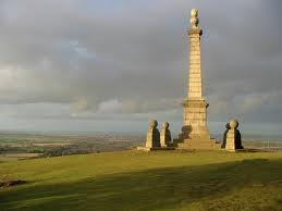 A pleasant walk through the woods led
out onto a spectacular edge of grassy down-land which terminated in Coombe Hill
and its monument. Here was a magnificent view, with Aylesbury at its focal
point. I chatted briefly with a girl runner, originally from Oswaldtwistle, who
pointed out some of the sights to be seen. My earlier loss of time did not
allow me to linger and, as the girl started her jog downwards, I followed as
quickly as I could down to Wendover. The route goes right into the town before
turning up a narrow path between the houses and out passed the church.
A pleasant walk through the woods led
out onto a spectacular edge of grassy down-land which terminated in Coombe Hill
and its monument. Here was a magnificent view, with Aylesbury at its focal
point. I chatted briefly with a girl runner, originally from Oswaldtwistle, who
pointed out some of the sights to be seen. My earlier loss of time did not
allow me to linger and, as the girl started her jog downwards, I followed as
quickly as I could down to Wendover. The route goes right into the town before
turning up a narrow path between the houses and out passed the church.The good weather had now deserted me. The clouds had rolled in and, by the time I had climbed out of town and through the woods, it has started to rain. So for the first time in the entire walk, it was out with the waterproofs. The drizzle got more and more persistent as I entered Tring Park, an attractive high country estate above the town. The rain was dripping off the avenues of trees and the path down to the A41 became slippery. Tring Station is a long way out of Tring and at the foot of the next (and last) big climb. Half way up the slippery scramble, I was passed by a serious fell runner who was motoring over the difficult terrain. The climb brought me out of the woodland onto a bare and grassy summit where the wind was so strong that I was struggling to make progress. It was stormy and wild as I descended to a road crossing.
Thence onto the very last section up to Ivinghoe Beacon. It was a relief to pull up the final mound onto the trig point and viewing place. But the weather was so unpleasant that I again did not linger but set off straight down the steep face of the hill. And straight into trouble. In seconds I was in skin-ripping brambles and long scrub. So bad was it that I had to reverse my route and go back over the summit and back to the access road at its rear. This lost me more time so I ran down the busy main road into Ivinghoe village where I came to a road sign that said 'Cheddington 3 miles'. My heart sank as I now had less than an hour to the train. A quick look at the bus times showed me that I only had one method of transport available, so I set off at a slow jog down the very busy and wet road. It really was miserable conditions now and only movement kept me warm. After half an hour I saw a farmer getting out of his tractor so I went over and asked how far it was to the station. What an incredible reply! Just 50 yards down the road to the left. I was there! The station was a mile before the village so had only been two miles out of Ivinghoe.
So I had half an hour to spare which gave me time to cross over to the deserted platform and strip off my wet clothes in the shelter on Platform 3. When the train arrived, I was back in civilian clothes and was warm dry and ready for the trip home. The 30 minute change at Milton Keynes allowed me to grab a cappuccino and pastry before the fast train took me to Stoke in exactly the hour. I was back in Macclesfield by 6.20pm and had time for a pint or two before walking home to prepare for the arrival of my daughter and her family, coming to stay for the half term holidays. No time to worry about tiredness and sore feet. The grandchildren burst into the house within minutes of my arrival and I was back in the real world.
Cadsden dep. 08.45, Ivinghoe Beacon 14.25, Cheddington Station arr. 15.30
GPS 22.28 in 6hrs 50