Introduction
Friday 5th August 2016
I was
getting desperate for a good walk but the weather this summer has not been conducive.
It had not turned out to be the monsoon season forecast by climate change
models; just day after day of grey skies and drizzle. Then suddenly there was a
hint of high pressure offering a weekend of sunshine. So, on the spur of the
moment, I grabbed my guidebook to the St Oswald’s Way, spent a morning on-line
booking the hotels and b&b’s, bought my train tickets and packed my
rucksack. 48 hours later I was on the train to Carlisle and Hexham.
The tide
tables determined which direction I was to walk in. The afternoon low tides
made it more suitable for a late finish of the northward walk rather than an
early start needed for a north-south journey. I was really pleased and pretty
amazed I had managed to get the accommodation sorted out at such a busy time in
the holiday season. Then I got a phone call from the Knowesgate Inn telling me
that, although I had booked a room and had a receipt, they had no accommodation
for me. I could either panic and cancel, or stay cool and carry on in the hope
that a bed would be found. Then it was
off to the station and into the unknown. I travelled via Manchester Piccadilly
and Carlisle to catch an early evening train to Hexham, The promised better
weather was beginning to appear.
I stayed at the
Station Inn in Hexham. My meal was spicy chicken, chips and peas and the beer
was the excellent Allendale Golden Plover (4%).
Saturday 6th August 2016 Hexham
- Knowesgate
Heaven on the Wall
It was a
beautiful morning, just as forecast. I went up into Hexham town centre to find
an ATM and the bus station. As I was so early, I decided to forsake public
transport and walk up to the official start at Heavenfield. So I turned back
across the railway line and crossed the Tyne. The Pennine Journey route was
marked on my map so I initially followed this to the footbridge across the A69
and beyond. The map was then rather confusing and I found myself on a lane
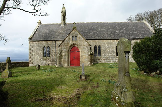
rather than in a field. But it revealed a gem of an old church, St John of Beverley
near Acomb. I spent a few minutes in the church in quiet contemplation and then
came out to talk to a lady, Sheila Smith, who had just finished writing a
history of the church and is in the process of getting it published. She
suggested that I write to the rectory next year to get a copy. Amazingly this
was the very day of an annual pilgrimage from Hexham Abbey up to the chapel at
Heavenfield to mark the anniversary of St Oswald’s death in battle (5th
August 642).
 Then it was
onwards and upwards along the very quiet lanes until I could cut across some
fields up to the road along Hadrian’s Wall. I had to deviate westward for a few
hundred yards to get access to the Hadrian’s Wall Path but I was soon heading
in the right direction up to the large cross and chapel at Heavenfield. Here a
couple were struggling to erect a small marquis from which to sell teas to the
afternoon pilgrims. I could not wait; I had a long day in front of me. So,
after a brief glance inside the chapel and then offering a helping hand in the
tent erection process, I set out along the National Trail. This I followed for
five or six miles to Halton Shields where my Way turned northwards along field
paths passed at old windmill and into to Great Whittington. Here the pub, a
Chinese restaurant, was closed. It was getting hot now and, in the total
absence of any refreshment emporium, I sat on the grass for a few moments near
to Click ‘em In Farm. The route-finding across the next hill was rather tricky
but I eventually found the correct line and dropped down to a road and war
memorial. Here a runner came towards me, a lad reccying the route for a race
along its entire length next month. Two more miles of road took me to Little
Bavington where a series of field paths led uphill passed Clay Walls Farm.
Here, coming towards me through a herd of very frisky cattle, was another
runner making the same reccy. He has the courtesy to come turn back with me and
help me through the rampant beasts. More
farmland was crossed until I could see Kirkwhelpington ahead and on the hill above it,
my destination. The rough ground up this last hill was not my most pleasant memory
of the day but I was soon on the lane that led to the hotel at Knowesgate.
Then it was
onwards and upwards along the very quiet lanes until I could cut across some
fields up to the road along Hadrian’s Wall. I had to deviate westward for a few
hundred yards to get access to the Hadrian’s Wall Path but I was soon heading
in the right direction up to the large cross and chapel at Heavenfield. Here a
couple were struggling to erect a small marquis from which to sell teas to the
afternoon pilgrims. I could not wait; I had a long day in front of me. So,
after a brief glance inside the chapel and then offering a helping hand in the
tent erection process, I set out along the National Trail. This I followed for
five or six miles to Halton Shields where my Way turned northwards along field
paths passed at old windmill and into to Great Whittington. Here the pub, a
Chinese restaurant, was closed. It was getting hot now and, in the total
absence of any refreshment emporium, I sat on the grass for a few moments near
to Click ‘em In Farm. The route-finding across the next hill was rather tricky
but I eventually found the correct line and dropped down to a road and war
memorial. Here a runner came towards me, a lad reccying the route for a race
along its entire length next month. Two more miles of road took me to Little
Bavington where a series of field paths led uphill passed Clay Walls Farm.
Here, coming towards me through a herd of very frisky cattle, was another
runner making the same reccy. He has the courtesy to come turn back with me and
help me through the rampant beasts. More
farmland was crossed until I could see Kirkwhelpington ahead and on the hill above it,
my destination. The rough ground up this last hill was not my most pleasant memory
of the day but I was soon on the lane that led to the hotel at Knowesgate.
Hexham dep. 08.45,
Knowesgate arr. 17.25 GPS 23.93 miles in
8hr 16m 57s moving plus a 10 min lunch stop near Great Whittington.
I stayed at
the Knowesgate Inn which did have a room ready for me despite my worst fears.
This hotel has gained a poor reputation and it is not the Ritz. It is a
roadside inn that it developing as a motel. I found it fun to stay there and I
enjoyed a great meal of lamb shank. The only real ale was in bottles (Doombar 4%)
but I was desperate so I had two.
Sunday 7th August 2016 Knowesgate
– Weldon
With a Following Wind
A great wind
had arisen during the night and it looked quite wild from the breakfast table.
So I donned a waterproof before venturing outside but the rain held off and it acted
more as a windproof. I was blown across the high farmland and passed the
plantations. Eventually I arrived at the entrance to Harwood Forest and, from
thereon, it was more sheltered. The route through the forest was mostly on wide
tracks although there were a couple of sections on narrow overgrown paths. The
way rose gentle until it suddenly exited the forest at the highest point on the
entire five days. I burst out of the trees at Cairn Coquet onto magnificent
mountain scenery with Simonside away to the left. The section across to Spylaw
Farm was probably the best of the whole route. Then it was down to the car park
at Lordenshaws and round the iron-age fort to reach the final steep descent
into Rothbury. Crossing the bridge, I was faced with an attractive looking café
(Tomlinson’s) and was soon ensconced with coffee and scones.
 The short
afternoon section began by re-crossing the bridge and proceeding along a road
and old railway line along the right bank of the River Coquet. The route did not
follow the river but scrambled up and down surrounding countryside to steer in
a straight line as the river meandered on its way. After passing several farms,
a farm track led to a lane and a short section on tarmac. The last couple of
miles into Weldon Bridge looked simple on the map but caused me a few
route-finding problems. I ended up asking the way from a very helpful local who
invited me to climb her garden fence to get back onto the right of way. The
last area of woodland, passing a weir in the river, was very fiddly and I was
quite relieved to pull out onto the road and cross the old bridge. The hotel
was immediately on the other side.
The short
afternoon section began by re-crossing the bridge and proceeding along a road
and old railway line along the right bank of the River Coquet. The route did not
follow the river but scrambled up and down surrounding countryside to steer in
a straight line as the river meandered on its way. After passing several farms,
a farm track led to a lane and a short section on tarmac. The last couple of
miles into Weldon Bridge looked simple on the map but caused me a few
route-finding problems. I ended up asking the way from a very helpful local who
invited me to climb her garden fence to get back onto the right of way. The
last area of woodland, passing a weir in the river, was very fiddly and I was
quite relieved to pull out onto the road and cross the old bridge. The hotel
was immediately on the other side.
Knowesgate dep.
08.42, Weldon arr. 16.40, GPS 21.10 miles in 7hrs 31m 00s walking time plus a 35 minute
lunch stop (13.45-14.20) in Rothbury.
I stayed at the Anglers Arms in Weldon, having a magnificent
meal of belly pork and blue cheese sauce followed by ginger sponge and custard.
The Hobgoblin Gold (4.5%) was very well kept on hand pump. A truly wonderful
hotel.
Monday 8th August 2016 Weldon – Alnmouth
Medieval Tournaments
A storm had
raged all through the night. At one point I got up to close the bedroom windows
as the howling wind was shaking the room. But the sun was shining as I left the
hotel and there was not a cloud in the sky. The first few yards were not
consistent with the guide book. The signed route went under the A697 on an
anglers' path along the riverbank before turning uphill back to the farm track.
This was followed for some way and it was very easy going compared with
yesterday. Except for one section of overgrown path, the section to Felton was
a walk in the park. In fact that was just where it ended up, passing under the
A1 and out into Felton Park with its peaceful old church in the trees to the
left. I immediately came upon another church, this one being the parish church
noticeable for its very low roof over the nave. Keeping to my pilgrimage
objectives, I spend five minutes inside before descending to the attractive bridge
over the river. The route continued along the right bank of the river into a
very flat section of farm tracks, fields and narrow lanes. I passed under the
East Coast Main Line which was to feature again later in my journey. Then the
way turned left onto a tarmacked bridleway which led directly into Warkworth. I
could see the castle up ahead with its flag flying in the sunshine. The castle
was pack out with visitors watching re-enactments of medieval tournaments. However
I could still buy a ticket to view the castle and I spent a wonderful half hour
watching the pageants from the majestic old keep. Then it was a quick dash into
town to get a coffee and Victoria sponge cake.

Weldon dep.
09.14, Alnmouth arr. 16.20, GPS 17.47 miles in 6hr 04m 30s walking time plus a
70 min break in Warkworth to see the castle and have some refreshments.
I stayed at the
Old Granary in Northumberland Street in Alnmouth. I ate at the Sun Inn, duck confit
with a couple of pints of Golden Sheep (4.7%) from Black Sheep Brewery.
Tuesday 9th August 2016 Alnmouth – Seahouses
Pub and Castle
Last night’s
rain had cleared as I set out under blue skies into a chill north westerly.
This blew in cloud and light drizzle as the day went on and I ended up wearing
my waterproof (just to keep warm). The route left Alnmouth over two golf
courses, the second of these, Foxton Hall, led me back to the beach. I tramped
up the wet sand to Boulmer and then went ashore onto wonderful grassy tracks
round headland after headland. This brought me to Craster where the smoke was
seeping out of the roof of the fish-smoking house. I hope they have got
authorisations for the air emissions.
 Beyond
Craster, the way is over well-walked grassland dominated by the view of
Dunstanburgh Castle on the next headland. It must be one of the most evocative
sights in England. There was little point in stopping to view the ruin: it is
best seen from a distance. So I hurried on into a wetting drizzle and quickly
came round to the tiny hamlet of Low Newton and shot into the Ship Inn with is
Brewhouse. I tried a pint of their home brew and sat outside with a bag of
peanuts. But it was too cold to sit for long and there was more drizzle in the
air.
Beyond
Craster, the way is over well-walked grassland dominated by the view of
Dunstanburgh Castle on the next headland. It must be one of the most evocative
sights in England. There was little point in stopping to view the ruin: it is
best seen from a distance. So I hurried on into a wetting drizzle and quickly
came round to the tiny hamlet of Low Newton and shot into the Ship Inn with is
Brewhouse. I tried a pint of their home brew and sat outside with a bag of
peanuts. But it was too cold to sit for long and there was more drizzle in the
air.
I continued along
the coast path passing several groups of youngsters practising for their Duke
of Edinburgh’s next month. More grass and golf courses took me to Beadnell, a
not very attractive village of bungalows facing the sea. I took to the beach
again north of the last house to avoid two miles of road walking and then had
to scramble up through the dunes back to the road to get over the next stream.
A fun-fare was making a racket as I entered Seahouses and here I turned right
over another golf course to reach the last headland before the harbour. I followed
Main Street through the town centre and out to the edge of town to find my accommodation
for the night. I showered and changed so that I could have a quick look around
the shops and harbour, but I easily succumbed to temptation and slipped into
the Olde Ship Inn for a pint.
Alnmouth dep.
08.54, Seahouses arr. 15.35, GPS 18.31 miles in 6hrs 13m 38s walking time with a
pub stop at the Ship in Low Newton (13.30 – 14.10). Drank a pint of Sandcastles
at Dawn (3.8%) brewed at the pub.
I stayed at
Ugiebrae, Main Street, Seahouses. I had a drink in the Olde Ship Inn, Sundancer
(3.5%) from High House Farm Brewery and ate at the Spice Garden Indian
Restaurant (yes, you’ve guessed, it was Cobra beer!)
Wednesday 10th August 2016 Seahouses - Lindisfarne
End of a Pilgrimage
I was early
down for breakfast with my rucksack packed and ready to go. There was to be no
easy start today. I had a bus to catch! I strode up the old railway line out of
Seahouses, seeking the inland route over to Bamburgh. This was a mixture of
fields and lanes, with little sign of them ever being used. Most walkers must
go down the foreshore. I found myself on the road beside the castle which was a
dominant feature above the village. I took the unofficial way across the
cricket pitch and through the dunes but I was soon back on the road to the golf
course. I crossed the course to Budle Point and then turned inland following
the signs. I then met a section with clear metal signs taking me across and out
of a caravan site. This left me on a lane which led up to the very busy B1342
where I had to turn left back towards Bamburgh to pick up the route again. I
probably put on an extra half a mile in getting round this dubious unofficial diversion.
Then there was a fiddley section around Wetton Mill before I got back onto a
field path with a purpose.
I followed a
series of roller-coaster fields until I could see Belford below me. I headed
down to a crossing of the east coast main line which instructed me to ring the
nearby signal box before crossing. I then came across the A1 with standing
traffic following an accident: Through the village it was quiet and then I left
town via Westhall after which I made a pig's ear of route finding up to
Plantation Farm. Although there was no trod on the ground the way to Swinhoe
Farm was more obvious. I then picked up a wide forest track that wound passed
some reservoirs. Here I had my only stop of the day, just a ‘splash and dash’.
 Just beyond
this point, the route was joined by St Cuthbert’s Way which I followed down
through fields and woods out onto the lane to Fenwick Here it started raining in earnest and I was
fully coated in rain-proofs as I crossed the A1 and came upon a party of Germans
waiting to re-cross the east coast main line. Again the signalman was rung but
this time the answer was ‘nein’. The Germans were momentarily confused but soon
realised why when a Virgin train thundered passed on its way to Kings Cross. A
second ‘phone call gave us the all clear and I was away passed the party of
walkers and heading for the causeway. It would probably have been safe to cross
the staked line across the sands but it was raining again and the route looked
very wet and muddy. So I chickened out and set out along the busy road. I was
soon able to get off tarmac onto the verge. The town of Lindisfarne took an age
to get closer as the causeway curved around in a great arch. But eventually,
with the rain now quite heavy, I came to the last bend before the packed car
park. I continued quickly passed and on to the Priory where I gave my thanks to
St Aidan for a pilgrimage safely and successfully completed.
Just beyond
this point, the route was joined by St Cuthbert’s Way which I followed down
through fields and woods out onto the lane to Fenwick Here it started raining in earnest and I was
fully coated in rain-proofs as I crossed the A1 and came upon a party of Germans
waiting to re-cross the east coast main line. Again the signalman was rung but
this time the answer was ‘nein’. The Germans were momentarily confused but soon
realised why when a Virgin train thundered passed on its way to Kings Cross. A
second ‘phone call gave us the all clear and I was away passed the party of
walkers and heading for the causeway. It would probably have been safe to cross
the staked line across the sands but it was raining again and the route looked
very wet and muddy. So I chickened out and set out along the busy road. I was
soon able to get off tarmac onto the verge. The town of Lindisfarne took an age
to get closer as the causeway curved around in a great arch. But eventually,
with the rain now quite heavy, I came to the last bend before the packed car
park. I continued quickly passed and on to the Priory where I gave my thanks to
St Aidan for a pilgrimage safely and successfully completed.
Seahouses dep.
08.24, Lindisfarne Priory arr. 16.04, GPS 23.82 in 7hrs 36min 40sec walking
time and a five minute break for an energy gel.
I changed
out of my wet walking clothes in the gents’ toilet. Then I checked the bus
times and went across the road for a coffee and carrot cake. Leaving it late to
go out into the rain once more, I got back to the bus stop to find a long
queue. For a few moments I thought I was in danger of not getting on but the
bus driver packed us all in with standing room only for several passengers. I
had been chatting in the queue with John from Hull who was also desperate to
get off the island and catch a train. So when the bus pulled into the station
car park at Berwick, he and I shot into the nearest pub for a very quick pint,
Belhaven (it is near Scotland!), but I was dying of thirst. Back on the
platform, John and I parted, he to go south and me to take a Cross-country
Train to Glasgow Central. This was generally on schedule and I had time to get
another ticket and jump on a Scot rail train to Ayr to visit my daughter and
grandchildren.
I had walked 104 miles on a very diverse route of moor and mountain, river bank and coast path. I now needed a rest but was unsure whether a few days with the grandkids was going to provide it.